New York City MTA Large NYC Subway Train Map and 50 similar items


New York City MTA Large NYC Subway Train Map + Free Vintage Style Art Print
$4.71
View full item details »

Shipping options
Seller handling time is 5 business days Details
$5.69 to United States
Return policy
None: All purchases final
Purchase protection
Payment options
PayPal accepted
PayPal Credit accepted
Venmo accepted
PayPal, MasterCard, Visa, Discover, and American Express accepted
Maestro accepted
Amazon Pay accepted
Nuvei accepted
View full item details »
Shipping options
Seller handling time is 5 business days Details
$5.69 to United States
Return policy
None: All purchases final
Purchase protection
Payment options
PayPal accepted
PayPal Credit accepted
Venmo accepted
PayPal, MasterCard, Visa, Discover, and American Express accepted
Maestro accepted
Amazon Pay accepted
Nuvei accepted
Item traits
| Category: | |
|---|---|
| Quantity Available: |
3 in stock |
| Condition: |
New |
| Country/Region of Manufacture: |
United States |
| Type: |
Subway Map |
| Free Bonus:: |
Astoria Queens Watercolor Print |
| MPN: |
Map + Vintage Brooklyn Bridge |
| Free Bonus: |
Astoria Queens Watercolor Print |
Listing details
| Seller policies: | |
|---|---|
| Shipping discount: |
No combined shipping offered |
| Posted for sale: |
More than a week ago |
| Item number: |
1584165852 |
Item description
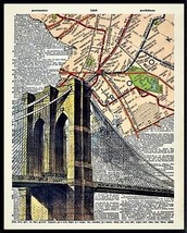
Official New York City MTA NYC Subway Train
Map
Plus free Vintage style Brooklyn Bridge
Map art print 8.5" x 11"
Official New York City MTA NYC Subway Train Map
February 2020 Edition
Plus free Art print of the Brooklyn map Brooklyn Bridge
" The Map "
New York City MTA NYC Subway Car Train Map
Explore the Big Apple like a local with the Official New York City CURRENT EDITION MTA NYC Subway LIRR Train Map!
This 23" x 28" foldout subway map is your ultimate guide to navigating the bustling streets of New York City with ease.
Featuring the most up-to-date information from the Metropolitan Transportation Authority (MTA), this CURRENT EDITION map is your go-to resource for planning your subway and LIRR train routes. With detailed, easy-to-read maps of all subway lines and Long Island Rail Road (LIRR) routes, this foldout map is compact and convenient to carry in your bag or pocket, making it perfect for both tourists and locals alike. Also great for map collectors', train enthusiasts, or ex New Yorkers wanting a little memorobilia.
Whether you're exploring the iconic landmarks of Manhattan, catching a Broadway show, or hopping on the LIRR to venture out to Long Island, this map has you covered. It also includes helpful information on station closures, transfer points, and fare zones, making it a comprehensive tool for navigating the city's extensive public transportation system.
Printed on high-quality paper, this Official New York City CURRENT EDITION MTA NYC Subway LIRR Train Map is durable and easy to handle, making it a practical and reliable resource for all your travel needs in the Big Apple. The large size of 23" x 28" when unfolded provides clear and legible details, making it easy to plan your routes and get around the city with confidence.
Don't get lost in the maze of New York City's subway system -
Get your hands on the Official New York City CURRENT EDITION MTA NYC Subway LIRR Train Map today and travel like a pro!
Features:
Covers New York City Subway with Bus Rail connections
Metro North Long Island Rail Road map on reverse side
New York Brooklyn Bronx Queens Staten Island
Own a piece of New York City
Great collectible Souvenir
A must have for every New Yorker
Great to have when your phone has no signal !
Brand New mint condition
Comes neatly folded
Ships immediately
Map size is about 23" x 28"
Print is 8.5" x 11" on standard paper.
10% of the sale of this item will benefit Direct Relief
Direct Relief improves the health and lives of people affected by poverty and emergency situations by equipping healthcare facilities in resource-poor areas with medicines and supplies. Direct Relief provides support in more than 90 countries and all 50 U.S. states, both on an ongoing basis and during emergency situations.
New York City NYC Manhattan Brooklyn Queens MTA Subway Car Train Map Poster
Official New York City MTA NYC Subway Train Map February 2020 Edition Plus free Art print of the Brooklyn map amp; Brooklyn Bridge " The Map " New York City MTA NYC Subway Car Train Map Explore the Big Apple like a local with the Official New York City CURRENT EDITION MTA NYC Subway amp; LIRR Train Map! This 23" x 28" foldout subway map is your ultimate guide to navigating the bustling streets of New York City with ease. Featuring the most up-to-date information from the Metropolitan Transportation Authority (MTA), this CURRENT EDITION map is your go-to resource for planning your subway and LIRR train routes. With detailed, easy-to-read maps of all subway lines and Long Island Rail Road (LIRR) routes, this foldout map is compact and convenient to carry in your bag or pocket, making it perfect for both tourists and locals alike. Also great for map collectors', train enthusiasts, or ex New Yorkers wanting a little memorobilia. Whether you're exploring the iconic landmarks of Manhattan, catching a Broadway show, or hopping on the LIRR to venture out to Long Island, this map has you covered. It also includes helpful information on station closures, transfer points, and fare zones, making it a comprehensive tool for navigating the city's extensive public transportation system. Printed on high-quality paper, this Official New York City CURRENT EDITION MTA NYC Subway amp; LIRR Train Map is durable and easy to handle, making it a practical and reliable resource for all your travel needs in the Big Apple. The large size of 23" x 28" when unfolded provides clear and legible details, making it easy to plan your routes and get around the city with confidence. Don't get lost in the maze of New York City's subway system - Get your hands on the Official New York City CURRENT EDITION MTA NYC Subway amp; LIRR Train Map today and travel like a pro! Features: Covers New York City Subway with Bus amp; Rail connections Metro North Long Island Rail Road map on reverse side New York Brooklyn Bronx Queens Staten Island Own a piece of New York City Great collectible Souvenir A must have for every New Yorker Great to have when your phone has no signal ! Brand New mint condition Comes neatly folded Ships immediately Map size is about 23" x 28" Print is 8.5" x 11" on standard paper. 10% of the sale of this item will benefit Direct Relief Direct Relief improves the health and lives of people affected by poverty and emergency situations by equipping healthcare facilities in resource-poor areas with medicines and supplies. Direct Relief provides support in more than 90 countries and all 50 U.S. states, both on an ongoing basis and during emergency situations. New York City NYC Manhattan Brooklyn Queens MTA Subway Car Train Map Poster
Official New York City MTA NYC Subway Train
Map
Plus free Vintage style Brooklyn Bridge
Map art print 8.5" x 11"
Official New York City MTA NYC Subway Train Map
February 2020 Edition
Plus free Art print of the Brooklyn map Brooklyn Bridge
" The Map "
New York City MTA NYC Subway Car Train Map
Explore the Big Apple like a local with the Official New York City CURRENT EDITION MTA NYC Subway LIRR Train Map!
This 23" x 28" foldout subway map is your ultimate guide to navigating the bustling streets of New York City with ease.
Featuring the most up-to-date information from the Metropolitan Transportation Authority (MTA), this CURRENT EDITION map is your go-to resource for planning your subway and LIRR train routes. With detailed, easy-to-read maps of all subway lines and Long Island Rail Road (LIRR) routes, this foldout map is compact and convenient to carry in your bag or pocket, making it perfect for both tourists and locals alike. Also great for map collectors', train enthusiasts, or ex New Yorkers wanting a little memorobilia.
Whether you're exploring the iconic landmarks of Manhattan, catching a Broadway show, or hopping on the LIRR to venture out to Long Island, this map has you covered. It also includes helpful information on station closures, transfer points, and fare zones, making it a comprehensive tool for navigating the city's extensive public transportation system.
Printed on high-quality paper, this Official New York City CURRENT EDITION MTA NYC Subway LIRR Train Map is durable and easy to handle, making it a practical and reliable resource for all your travel needs in the Big Apple. The large size of 23" x 28" when unfolded provides clear and legible details, making it easy to plan your routes and get around the city with confidence.
Don't get lost in the maze of New York City's subway system -
Get your hands on the Official New York City CURRENT EDITION MTA NYC Subway LIRR Train Map today and travel like a pro!
Features:
Covers New York City Subway with Bus Rail connections
Metro North Long Island Rail Road map on reverse side
New York Brooklyn Bronx Queens Staten Island
Own a piece of New York City
Great collectible Souvenir
A must have for every New Yorker
Great to have when your phone has no signal !
Brand New mint condition
Comes neatly folded
Ships immediately
Map size is about 23" x 28"
Print is 8.5" x 11" on standard paper.
10% of the sale of this item will benefit Direct Relief
Direct Relief improves the health and lives of people affected by poverty and emergency situations by equipping healthcare facilities in resource-poor areas with medicines and supplies. Direct Relief provides support in more than 90 countries and all 50 U.S. states, both on an ongoing basis and during emergency situations.
New York City NYC Manhattan Brooklyn Queens MTA Subway Car Train Map Poster
|
Why are we showing these items?
Search Results
Map, transportation"map" Category "Transportation"
Material
Handmade
Handmade
|


 - $46.53")


-
Refine your browsing experience
We can show you more items that are exactly like the original item, or we can show you items that are similar in spirit. By default we show you a mix.


This item has been added to your cart
 New York City MTA Large NYC Subway Train Map + Free Vintage Style Art Print added to cart.
3 available in stock
New York City MTA Large NYC Subway Train Map + Free Vintage Style Art Print added to cart.
3 available in stock
View Cart or continue shopping.
 Please wait while we finish adding this item to your cart.
Get an item reminder
We'll email you a link to your item now and follow up with a single reminder (if you'd like one). That's it! No spam, no hassle.
Already have an account?
Log in and add this item to your wish list.