Vintage 60’s USGS Topo Map Blackcap Mountain and 50 similar items


Vintage 60’s USGS Topo Map Blackcap Mountain Maxon Dome Fresno CA Original Chart
$19.75
View full item details »
Shipping options
Return policy
None: All purchases final
Purchase protection
Payment options
PayPal accepted
PayPal Credit accepted
Venmo accepted
PayPal, MasterCard, Visa, Discover, and American Express accepted
Maestro accepted
Amazon Pay accepted
Nuvei accepted
View full item details »
Shipping options
Return policy
None: All purchases final
Purchase protection
Payment options
PayPal accepted
PayPal Credit accepted
Venmo accepted
PayPal, MasterCard, Visa, Discover, and American Express accepted
Maestro accepted
Amazon Pay accepted
Nuvei accepted
Item traits
| Category: | |
|---|---|
| Quantity Available: |
Only one in stock, order soon |
| Condition: |
Unspecified by seller, may be new. |
| Type: |
Anthropomorphic Map |
| Maker: |
USGS |
| Original/Reproduction: |
Antique Original |
| Date Range: |
1960-1969 |
| Year: |
1953 |
| Country/Region: |
United States of America |
| US State: |
California |
| Mexican State: |
Nayarit |
| Format: |
Sheet Map |
| Printing Technique: |
Lithography |
| Cartographer/Publisher: |
Geological Survey Control |
| Feature Refinement: |
True Vintage Map |
| City: |
Black Cap Mountain |
| Publication Year: |
1962 |
| Canadian Province: |
N/A |
| Topic: |
Maps |
| Original Reproduction Reprint: |
Original |
Listing details
| Seller policies: | |
|---|---|
| Shipping discount: |
Shipping weights of all items added together for savings. |
| Posted for sale: |
April 16 |
| Item number: |
1739578506 |
Item description
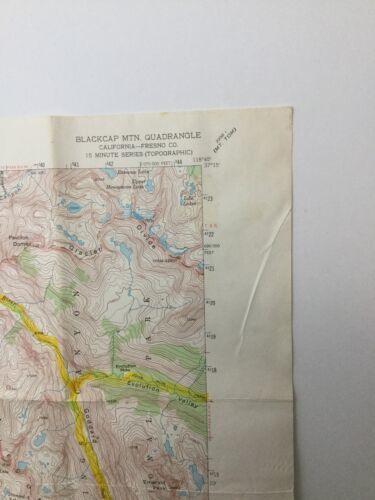
Blackcap Mtn. Quadrangle California-Fresno Co 15 Minute Series Topographic. Maxon Dome, Lost Canyon 1962 Vtg USGS Original Topo Chart Map. Marked N3700-W11845/15. Minor corrections made 1962 AMS 2258 III Series V795. Overall good condition, some yellowing, marks, and creases. Some staining on the backside of the map and top front of the map, shown in the photos. Map has been folded. No holes. Blackcap Mtn. 1,5 Calif. written in marker on the backside. Does not bleed through. Map measures approximately 21" tall x 17" wide. Printed area measures approximately 17.5" tall x 14" wide. Map will be delivered folded, as shown in the photo.


-
Refine your browsing experience
We can show you more items that are exactly like the original item, or we can show you items that are similar in spirit. By default we show you a mix.


This item has been added to your cart
 Vintage 60’s USGS Topo Map Blackcap Mountain Maxon Dome Fresno CA Original Chart added to cart.
Only one available in stock
Vintage 60’s USGS Topo Map Blackcap Mountain Maxon Dome Fresno CA Original Chart added to cart.
Only one available in stock
View Cart or continue shopping.
 Please wait while we finish adding this item to your cart.
Get an item reminder
We'll email you a link to your item now and follow up with a single reminder (if you'd like one). That's it! No spam, no hassle.
Already have an account?
Log in and add this item to your wish list.