HISTORIX Vintage 1875 Brigham City and Great and 50 similar items


Free Shipping
HISTORIX Vintage 1875 Brigham City and Great Salt Lake Utah Map Poster - 24x36 I
$59.99
View full item details »

Shipping options
Seller handling time is 1 business day Details
FREE via to United States
Return policy
Full refund available for DOAs
Details
Purchase protection
Payment options
PayPal accepted
PayPal Credit accepted
Venmo accepted
PayPal, MasterCard, Visa, Discover, and American Express accepted
Maestro accepted
Amazon Pay accepted
Nuvei accepted
View full item details »
Shipping options
Seller handling time is 1 business day Details
FREE via to United States
Return policy
Full refund available for DOAs
Details
Purchase protection
Payment options
PayPal accepted
PayPal Credit accepted
Venmo accepted
PayPal, MasterCard, Visa, Discover, and American Express accepted
Maestro accepted
Amazon Pay accepted
Nuvei accepted
Item traits
| Category: | |
|---|---|
| Quantity Available: |
8 in stock |
| Condition: |
New |
| UPC: |
705514886125 |
| MPN: |
ENMAP0616_2436 |
| Style: |
Vintage/Retro |
| ASIN: |
B0C4BWGH1T |
| EAN: |
0705514886125 |
| Bullet Point: | |
| Product Description: | |
| Brand: |
HISTORIX |
| Unspsc Code: |
55101500 |
| Externally Assigned Product Identifier: |
705514886125 |
| Item Type Keyword: |
artwork |
| size: |
36L" x 24W" |
| Paper Size: |
24 x 36 |
| Part Number: |
ENMAP0616_2436 |
| Wall Art Form: |
poster |
| Target Gender: |
unisex |
| Paint Type: |
Watercolor |
| Color: |
Natural |
| manufacturer: |
historix |
| Item Shape: |
Rectangular |
| orientation: |
Landscape |
| Paper Finish: |
matte |
| Item Name: | |
| Material: |
Paper |
| Mounting Type: |
Wall Mount |
Listing details
| Seller policies: | |
|---|---|
| Shipping discount: |
Seller pays shipping for this item. |
| Posted for sale: |
April 3 |
| Item number: |
1735807226 |
Item description
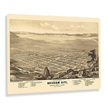
Brigham City is situated at the base of the Wellsville Mountains, part of the Wasatch Mountain Range. The Wasatch is the Western Edge of the Greater Rocky Mountains, and the region is home to many sources of fresh water, which made them ideal for the early settlers who established communities around them. Established by Mormon settlers during the 1850s, Brigham City had grown to be a hub for trade and developed a thriving industry that attracted residents in the decade following the conclusion of the American Civil War when railroad expansion had increased access to many remote parts of the American West.
Produced and published by Eli Sheldon Glover, this bird's eye perspective bears a distinctive style and unique aesthetic that immediately transports the viewer back in time, creating a link between the past and present. Panoramic maps were widely popular during the latter portions of the nineteenth century and early twentieth century. They served as marketing materials to attract residents and merchants alike by promoting prominent civic features and natural attractions. Brigham City's proximity to the Great Salt Lake also attracted residents looking to extract minerals from the region and transport them to markets in the Northeast.
The city experienced a significant population boom following World War II due to the formation of the ATK Thiokol corporation, which produced the rockets for the first space shuttles. By 1875 Brigham City remained a relatively remote enclave that continued to grow and evolve as the nation neared the turn of the century.
Additional Details
------------------------------
Bullet point: VINTAGE MAP REPRODUCTION: You?ll love this high quality historic reproduction of 1875 Brigham City and Great Salt Lake Utah Map Poster. Our museum quality prints are archival grade, which means it will look great and last without fading for over 100 years. Our print to order maps are made in the USA and each map is inspected for quality. This beautiful artwork is a perfect addition to your themed decor. Vintage maps look great in the home, study or office. They make a perfect gift as well.
Product description:
Brigham City is situated at the base of the Wellsville Mountains, part of the Wasatch Mountain Range. The Wasatch is the Western Edge of the Greater Rocky Mountains, and the region is home to many sources of fresh water, which made them ideal for the early settlers who established communities around them. Established by Mormon settlers during the 1850s, Brigham City had grown to be a hub for trade and developed a thriving industry that attracted residents in the decade following the conclusion of the American Civil War when railroad expansion had increased access to many remote parts of the American West.
Produced and published by Eli Sheldon Glover, this bird's eye perspective bears a distinctive style and unique aesthetic that immediately transports the viewer back in time, creating a link between the past and present. Panoramic maps were widely popular during the latter portions of the nineteenth century and early twentieth century. They served as marketing materials to attract residents and merchants alike by promoting prominent civic features and natural attractions. Brigham City's proximity to the Great Salt Lake also attracted residents looking to extract minerals from the region and transport them to markets in the Northeast.
The city experienced a significant population boom following World War II due to the formation of the ATK Thiokol corporation, which produced the rockets for the first space shuttles. By 1875 Brigham City remained a relatively remote enclave that continued to grow and evolve as the nation neared the turn of the century.
Style: Retro
|
Why are we showing these items?
Booth
Historic Prints |

|


-
Refine your browsing experience
We can show you more items that are exactly like the original item, or we can show you items that are similar in spirit. By default we show you a mix.


This item has been added to your cart
 HISTORIX Vintage 1875 Brigham City and Great Salt Lake Utah Map Poster - 24x36 I added to cart.
8 available in stock
HISTORIX Vintage 1875 Brigham City and Great Salt Lake Utah Map Poster - 24x36 I added to cart.
8 available in stock
View Cart or continue shopping.
 Please wait while we finish adding this item to your cart.
Get an item reminder
We'll email you a link to your item now and follow up with a single reminder (if you'd like one). That's it! No spam, no hassle.
Already have an account?
Log in and add this item to your wish list.