HISTORIX Vintage 1793 Kentucky Map - 12x24 and 50 similar items


Free Shipping
HISTORIX Vintage 1793 Kentucky Map - 12x24 Inch Vintage Map of Kentucky Poster -
$37.99 - $59.99
View full item details »

Shipping options
Seller handling time is 1 business day Details
FREE via to United States
Return policy
Full refund available for DOAs
Details
Purchase protection
Payment options
PayPal accepted
PayPal Credit accepted
Venmo accepted
PayPal, MasterCard, Visa, Discover, and American Express accepted
Maestro accepted
Amazon Pay accepted
Nuvei accepted
View full item details »
Shipping options
Seller handling time is 1 business day Details
FREE via to United States
Return policy
Full refund available for DOAs
Details
Purchase protection
Payment options
PayPal accepted
PayPal Credit accepted
Venmo accepted
PayPal, MasterCard, Visa, Discover, and American Express accepted
Maestro accepted
Amazon Pay accepted
Nuvei accepted
Item traits
| Category: | |
|---|---|
| Quantity Available: |
16 in stock |
| Condition: |
New |
| UPC: |
737214977278 |
| Item Name: |
1793 Kentucky State Poster Print |
| Item Type Keyword: |
prints |
| Unspsc Code: |
10111300 |
| sizes: |
Listing details
| Seller policies: | |
|---|---|
| Shipping discount: |
Seller pays shipping for this item. |
| Posted for sale: |
April 15 |
| Item number: |
1739664791 |
Item description
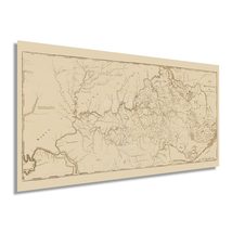
This is one of the earliest official depictions of the State of Kentucky and was produced one year after Kentucky’s admission into the United States as the fifteenth state. Numerous farms were being established in the region, which was famed for its fertile land and namesake Bluegrass which provided excellent grazing pastures for horses and livestock. The first European settlement in Kentucky was established in 1774 and began a period of growth as immigrants from France, Western Europe, and Great Britain flocked to the region and founded small villages based on cultural lines.
Originally Kentucky was the western portion of Virginia, though they gained the right to seek statehood in 1789. Access was relatively simple for immigrants who could journey down the Ohio River or overland through the Cumberland Gap. These early periods of settlement would go on to shape Kentucky’s rich history and distinct culture. The state would become one of the most important border states during the American Civil War and remained loyal to the Union during the conflict. The region experienced prolonged prosperity as an exporter of significant cash crops like wheat, hay, and tobacco fueled economic expansion. The unique geography that changes from the mountainous east to the rolling green hills in the west remains some of the most pastoral land in America.
The minimal style and classic aesthetic of this piece are very characteristic of productions from this era and display the advances made as technology improved in printing, illustration, and surveying occurred during the early twentieth century.
Our museum quality giclee print comes printed with archival ink on premium heavyweight matte paper. Shipped in a sturdy cardboard tube your print will arrive ready to be framed. This eye-catching vintage map reproduction print makes the perfect gift for anyone that loves history and imagery.
|
Why are we showing these items?
Booth
Historic Prints |

|


-
Refine your browsing experience
We can show you more items that are exactly like the original item, or we can show you items that are similar in spirit. By default we show you a mix.


This item has been added to your cart
 HISTORIX Vintage 1793 Kentucky Map - 12x24 Inch Vintage Map of Kentucky Poster - added to cart.
16 available in stock
HISTORIX Vintage 1793 Kentucky Map - 12x24 Inch Vintage Map of Kentucky Poster - added to cart.
16 available in stock
View Cart or continue shopping.
 Please wait while we finish adding this item to your cart.
Get an item reminder
We'll email you a link to your item now and follow up with a single reminder (if you'd like one). That's it! No spam, no hassle.
Already have an account?
Log in and add this item to your wish list.