Rendered at 17:47:47 05/21/25

Shipping options
Estimated to arrive by Tue, Jun 10th.
Details
FREE via UPS Ground (1 to 5 business days) to United States
Return policy
Replacement product available within 30 days
Details
Purchase protection
Payment options
PayPal accepted
PayPal Credit accepted
Venmo accepted
PayPal, MasterCard, Visa, Discover, and American Express accepted
Maestro accepted
Amazon Pay accepted
Nuvei accepted
Item traits
| Category: | |
|---|---|
| Quantity Available: |
Only one in stock, order soon |
| Condition: |
New |
| Country/Region of Manufacture: |
United States |
Listing details
| Seller policies: | |
|---|---|
| Posted for sale: |
More than a week ago |
| Item number: |
738142819 |
Item description
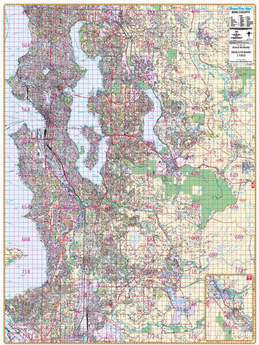
THOMAS BROS. SEATTLE WALL MAP (R)
DESCRIPTION
Rand McNally's ProSeries wall map of Seattle is ideal for anyone needing a comprehensive representation of the area for planning, routing, or reference. It's a great choice for business and sales strategy, urban development, social work outreach, education, and marketing.
Note: This map is not available for gift wrapping. Please allow 7-10 days for shipping.
Laminated wall map printed with UV-resistant ink to help prevent color fading
Map details include airports, hospitals, railroads, points of interest, shopping centers, parks, golf and country clubs, post offices, police and fire stations, schools and educational institutions, government buildings, mileage circles, block numbers, city limits and annexations, ZIP codes and boundaries, and much more
Includes a separate street index book (39 pages)
Hanging kit with rails for easy mounting
COVERAGE AREA
Coverage area extends:
North to the Snohomish/King County line
South to the Pierce/King County line, including Federal Way, Auburn, and Black Diamond
East to Carnation, and Snoqualmie
West to Puget Sound
Inset map of North Bend
PRODUCT DETAILS
Dimensions: 60" x 80"; Scale (in feet): 1:2,587.
Added to your wish list!
- THOMAS BROS. SEATTLE WALL MAP (R)
- 1 in stock
- Handling time 10 days. Estimated delivery: Tue, Jun 10th
- Returns/refunds accepted
Get an item reminder
We'll email you a link to your item now and follow up with a single reminder (if you'd like one). That's it! No spam, no hassle.
Already have an account?
Log in and add this item to your wish list.